Introduction
Geospatial data analysis is a significant field of study and work that involves understanding the spatial and geographic data to extract meaningful information. Python, as a programming language, offers robust libraries for handling geospatial data, and NumPy is one such library that’s quintessential in the manipulation of numerical data. This tutorial provides a comprehensive introduction to using NumPy for geospatial data analysis, starting from basic to advanced examples.
NumPy, short for Numerical Python, is a foundational package for scientific computing in Python. It provides a high-performance multidimensional array object, and tools for working with these arrays. When dealing with geospatial data analysis, arrays can represent raster datasets, points, or grids, which are commonplace in the field.
For following this guide, it’s assumed you have a basic understanding of Python and have NumPy installed in your environment. If not, you can install NumPy using pip:
pip install numpyBasic Array Operations
First, let’s start by importing NumPy and creating a simple array:
import numpy as np

# Creating a simple NumPy array
coordinates = np.array([[34, 45], [56, 67], [78, 89]])
print(coordinates)
Output:
[[34 45]
 [56 67]
 [78 89]]
This array can represent geographic coordinates with latitude and longitude pairs.
Basic Statistics
NumPy allows you to perform basic statistical analysis on your array data which is crucial in understanding geospatial patterns.
# Calculating mean of the coordinates
mean_coordinates = np.mean(coordinates, axis=0)
print("Mean Coordinates: ", mean_coordinates)

# Standard deviation
std_deviation = np.std(coordinates, axis=0)
print("Standard Deviation: ", std_deviation)
Output:
Mean Coordinates:  [56. 67.]
Standard Deviation:  [17.74823935 17.74823935]
Working with Rasters
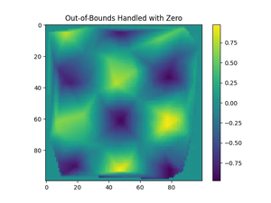
Raster data represents a matrix of cells or pixels with values representing a spatial area. Suppose we’re dealing with elevation data as a raster, NumPy can handle the array manipulation tasks.
# Simulating a raster grid of elevations
elevation_data = np.random.rand(100, 100) * 1000  # Elevation in meters

# Inspecting the maximum elevation
max_elevation = np.max(elevation_data)
print("Max Elevation: ", max_elevation)
Output:
Max Elevation: 998.379263305Advanced Geospatial Operations
Leveraging NumPy, we can perform more complex geospatial analysis tasks such as defining functions to calculate the distance between points or applying a filter to a raster dataset.
For example, consider calculating the Euclidean distance between two points:
def euclidean_distance(point1, point2):
    return np.linalg.norm(np.array(point1) - np.array(point2))

# Calculating the distance between the first and second coordinates
distance = euclidean_distance(coordinates[0], coordinates[1])
print("Distance: ", distance)
Output:
Distance: 31.11269837220809We can also apply a Gaussian filter to smooth out a raster elevation dataset:
from scipy.ndimage import gaussian_filter

# Applying a Gaussian filter with a sigma of 1
smoothed_elevation = gaussian_filter(elevation_data, sigma=1)
Working with Geospatial Libraries
NumPy is often used in conjunction with other geospatial libraries such as GDAL, Fiona, and rasterio which provide more functionalities for working with geospatial datasets. For example, rasterio uses NumPy arrays to store raster data.
Installing rasterio can be done via pip:
pip install rasterioReading a GeoTIFF file and accessing its array data is straightforward:
import rasterio

# Reading a GeoTIFF file
with rasterio.open('path_to_your_geotiff.tif') as src:
    raster_array = src.read(1)  # Read the first band

# Now, raster_array is a NumPy array containing the raster data
Conclusion
In conclusion, NumPy provides powerful tools for geospatial data analysis, making it a staple in the geospatial analyst’s toolbox. With the ability to perform a wide range of data manipulations and apply statistical analyses, coupled with its integration with other geospatial libraries, NumPy is indispensable for anyone working with geospatial data in Python.